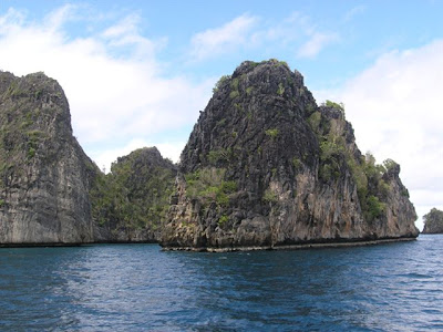
RAJA AMPAT ISLANDS WEST PAPUA INDONESIA
RAJA AMPAT ISLANDS WEST PAPUA INDONESIA
RAJA AMPAT ISLANDS WEST PAPUA INDONESIA
RAJA AMPAT ISLANDS WEST PAPUA INDONESIA
The Raja Ampat, or “Four Kings,” archipelago encompasses more than 9.8 million acres of land and sea off the northwestern tip of Indonesia’s West Papua Province. Located in the Coral Triangle, the heart of the world’s coral reef biodiversity, the seas around Raja Ampat possibly hold the richest variety of species in the world.
The Raja Ampat, or “Four Kings,” archipelago encompasses more than 9.8 million acres of land and sea off the northwestern tip of Indonesia’s West Papua Province. Located in the Coral Triangle, the heart of the world’s coral reef biodiversity, the seas around Raja Ampat possibly hold the richest variety of species in the world.
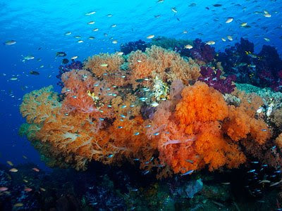
The area’s massive coral colonies show that its reefs are resistant to threats like coral bleaching and disease —threats that now jeopardize the survival of corals around the world. In addition, Raja Ampat’s strong ocean currents sweep coral larvae across the Indian and Pacific Oceans to replenish other reef ecosystems. Raja Ampat’s coral diversity, resilience to threats, and ability to replenish reefs make it a global priority for marine protection.
Survey Confirms Highest Marine Biodiversity on Earth
In 2002, The Nature Conservancy and its partners conducted a scientific survey of the Raja Ampat Islands to collect information on its marine ecosystems, mangroves, and forests. The survey brought Raja Ampat’s total number of confirmed corals to 537 species— an incredible 75% of all known coral species. In addition, 899 fish species were recorded, raising the known total for Raja Ampat to an amazing 1,074. On land, the survey found lush forests, rare plants, limestone outcroppings, and nesting beachesfor thousands of sea turtles.
Though human impacts here are less severe than elsewhere in Indonesia, Raja Ampat’s natural resources are endangered by over fishing and destructive fishing, turtle poaching, and unsustainable logging. The Indonesian government recently established Raja Ampat as a separate administrative unit, which will give communities a greater say in managing the natural resources upon which their livelihoods depend. This structure also offers an important opportunity to include conservation in the spatial planning of the newly formed local government.
Ensuring Conservation through Partnerships
To address these issues, the Conservancy launched a new project to protect Raja Ampat, working in close partnership with the government and communities to: 1) contribute to a comprehensive conservation action plan to protect Raja Ampat’s reefs and forests; 2) help incorporate marine protected area management into long-term planning and policy; and, 3) establish a network of marine protected areas for Raja Ampat.
The Conservancy’s ultimate goal is to protect Raja Ampat’s magnificent reefs while sustaining the livelihoods of local people. Raja Ampat includes the four large islands of Waigeo, Batanta, Salawati, and Misool, plus hundreds of smaller islands. The archipelago is part of an area known as the Bird’s Head functional seascape, which also contains Cenderawasih Bay, the largest marine national park in Indonesia.
Come and dive in Raja Ampat Islands with Our Liveaboards
Source:
www.rajaampatislands.com


 MIT Haystack radio Image


 Hanoi is located in the Red River Delta, in the center of North Vietnam. It is encompassed by Thai Nguyen, Vinh Phuc provinces to the north, Hoa Binh and Ha Nam to the south, Bac Giang, Bac Ninh and Hung Yen provinces to the east, Hoa Binh and Phu Tho to the west.
 Hanoi is a sacred land of Vietnam. In the 3rd century BC, Co Loa (actually belonging to Dong Anh District) was chosen as the capital of the Au Lac Nation of Thuc An Duong Vuong (the King Thuc). Hanoi later became the core of the resistance movements against the Northern invasions. Located in the middle of the Red River Delta, the town has gradually expanded to become a very populations and rich residential center. At different periods, Hanoi had been selected as the chief city of Vietnam under the Northern domination.In the autumn of Canh Tuat lunar years (1010), Ly Thai To, the founder of the Ly Dynasty, decided to transfer the capital from Hoa Lu to Dai La, and so he rebaptized it Thang Long (Soaring Dragon). The year 1010 then became an historical date for Hanoi and for the whole country in general. For about a thousand years, the capital was called Thang Long, then changing to Dong Do, Dong Kinh, and finally to Hanoi, in 1831. This sacred piece of land thereafter continued to be the theatre of many fateful events.
 Throughout the thousand years of its eventful history, marked by destruction, wars and natural calamities, Hanoi still preserves many ancient architectural works including the Old Quarter and over 600 pagodas and temples. Famous sites include the One Pillar Pagoda (built in 1049), the Temple of Literature (built in 1070), Hanoi Citadel, Hanoi Opera House, President Ho Chi Minh's Mausoleum...
 By road: Hanoi is 93km from Ninh Binh, 102km from Haiphong, 153km from Thanh Hoa, 151km from Halong, 474km from Dien Bien Phu, 658km from Hue, 763km from Danang, and 1,710km from Ho Chi Minh City.